• Home
  • Software
  • Wi-Fi
  • Videos
  • About US
  • Contact Us
  • Downloads

Technology at your finger tips

  • Home
  • Privacy Policy
  • Terms and Conditions
  • Disclaimers
  • Contact Us
> Home » How to Check Tower Height for Long distance Point to Point in Google Earth

How to Check Tower Height for Long distance Point to Point in Google Earth

May 21, 2018 by admin

A most important part of the wireless point to point connectivity is doing a proper site survey and feasibility test. Doing direct installation of the point to point connectivity may fail due to lack of planning before execution. See the details user guide of wireless PTP site survey of long-distance point to point to clear all obstacles in the linkway.

How to Check Wireless Point to Point Line Of sight in Google Earth

Point to Point (PTP) is wireless connectivity between two locations without any middle location called Point to point in Wireless technology. Today wireless technology growing very fast and because of Wireless, we can connect long distance network connectivity just using wireless radios. Where we required more than 2 months to lay a cable up to 30 KM distance, wireless can give you connectivity within 2 days. Wireless long distance point to point site survey provide you link distance by air with feasible or not for wireless connectivity.

  • Protect Network and Wireless Devices from Lighting and Thundering

Before the installation of wireless connectivity, the site survey must be required to ensure there is no obstacle between wireless connectivity and can connect the long distance point to point. Short distances like 500M, 1Km, 2Km distance can be physically inspected with eyes if there is anything disturbance in between but if Point to Point distance is more than 3 Km then its required a proper feasibility test for successful wireless connectivity.

  • 5 Best Long Range Wireless Point to Point Device for Internet and CCTV

In this post, I will describe how to check the feasibility for Point to point and point wireless long-distance link. There some steps to check the issue of wireless connectivity for long-distance. Making a proper wireless point to point survey save time as well as save the money.

How to Check Long Distance Point to Point Feasibility in Google Earth

To check line of sight for point to point and point-multipoint there are some tools and steps required before test it in Google Earth.

  1. GPS
  2. PC/Desktop
  3. Internet Connection

These three basic requirements for performing the PTP site survey & line of sight testing.

If you don’t have GPS and looking to buy a GPS device then you can check here.
How about GPS technology Work?
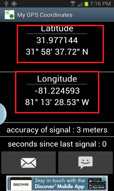
You can also use Smartphone GPS co-ordinate app to get the co-ordinate of both locations you want to point to point.

Get Android GPS Co-ordinate apps here now.


  • How to block any Website and Apps on basic WiFi Router
  • How to Do Wireless Point to Point and Hotspot Site Survey

How to Take GPS Co-Ordinate for PTP site survey

To check the point to point feasibility you have to go one by one to both locations you want to wireless connectivity. And take the GPS co-ordinate at both sites.

PTP site survey Location 1

  1. Once you visit location 1 for site survey before taking GPS coordinate note of the total building height at location 1. Building height will be required to calculate tower height for the feasibility test of Point to point link
  2. To take the GPS to coordinate if you are using Android Apps then GPS should enable in your smartphone.

Enable GPS from setting or top toggle bar menu.
Now open then GPS Co-ordinate apps in mobile.
Make sure you are in an open area GPS will not work on indoors so only take GPS to coordinate on the open area where GPS can connect to the satellite and give you the correct co-ordinate at the point you stand.
You will coordinate like this. See the below image. Save coordinate with location name.

Outdoor Bridge Range Calculation Utility


  • How to install CCTV camera in Lift using Wireless Device

PTP site survey Location 2

  1. Note the building height at location 2  now take the GPS coordinates.
  2. Open the GPS coordinate apps again and wait for getting coordinated at the site. Save the coordinate for a location name and now will check feasibility on Google earth.
  • How to use WhatsApp without Phone Number with Tricks
  • The Best Way to Boost Your Wi-Fi Speed Up to 10x  [Tricks]

How to Calculate Tower Height for Point to Point on Google Earth

After physically visited both points to point site now the final steps will be required where we know how to check tower height required for Point to Point and Point multipoint connectivity for short and long-distance. In this process, you will learn how to calculate building height and tower height for wireless link connectivity.  You can check exact link distance by air and feasibility test for point to point and point to multipoint wireless network connectivity.

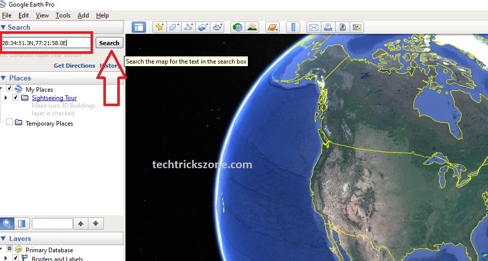
Install Google Earth on your computer.

This is both Location GPS coordinate I want to test feasibility.

       Location A-:  28°34’51.3N, 77°21’58.0E

       Location B–   28°35’28.1N, 77°19’59.09E

How to check Point to Point Link Air Distance with Google Earth?

When we check GPS coordinate of the different location in Google earth than fist we have to find both the places with GPS coordinate. Once you recognized the correct location we will test distance with Ruler tool available in Google Earth.

Follow the steps to test your site survey on Google earth.

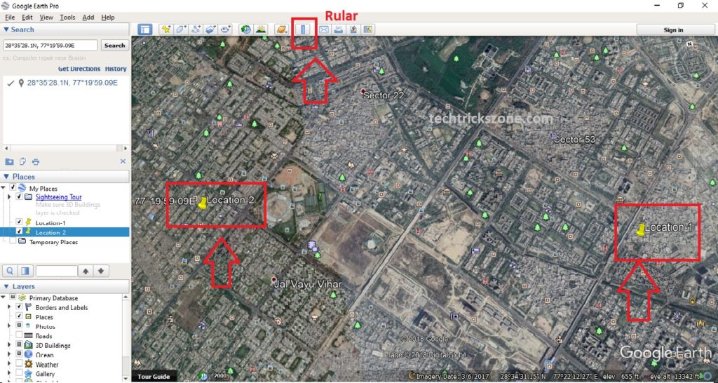
  1. Search the Location -1 GPS coordinates and Mark it with the name.

See the Search box in the left side menu bar- type your first location GPS coordinate or simply copy and paste it

Click the Search button.

Distance software


Now second steps mark the Location 1 search by Google earth to recognize in the future.

To add the placemark and name click on the Yellow Pin icon (Place Mark) and type location name.

If the Placemark pin is not the right place where you location coordinate showing move pin by mouse and click save button.

how to measure long distances feasibility


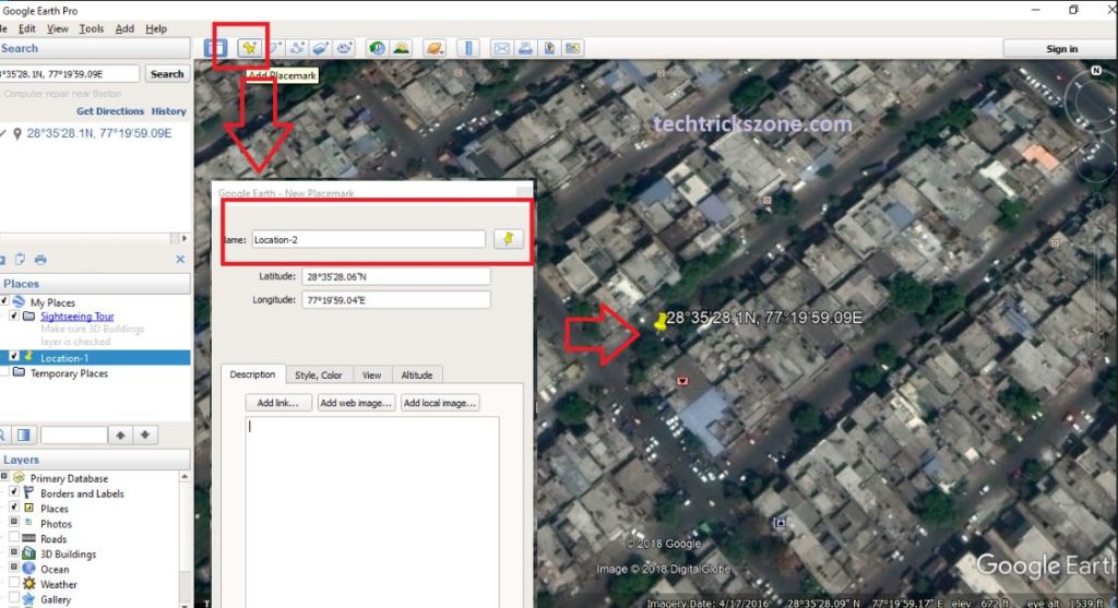
Search add Place Mark location 2 in Google Earth.

Now repeat the same steps for location 2 marking on Google earth.
Once you have added both locations of your Point to point connectivity.
Now measure the distance between Location 1 and location 2.
You can only propose the correct wireless device once you have calculated air distance correctly. To check air distance from point to point see below steps.

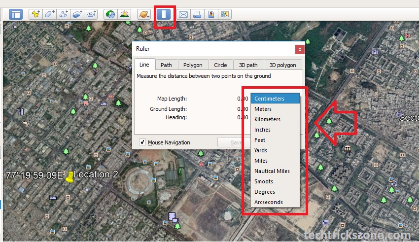
Ruler Tools in Google Earth  | Distance Calculation For Point to Point Connectivity

To check Air distance of the point to point or point to multipoint there is a tool called Ruler on Google earth. You can check any long-distance exact air distance with the help of these tools.

Now zoom in your Google earth and show both the location in your screen show you can check air distance.

Point to Point Wireless | Wireless Bridging


  1. Now both the location visible on the screen so I can measure the distance.
  2. Click Ruler tools on the top menu and select the measurement unit you want to use.
  3. AS given Units you can use anyone like Centimetres, meters, Kilometre ..etc

How to build WiFi hotspot having 10 KM range


Now you will get the Square box in ruler curser.  Click on location 1 and move it toward location 2 and release mouse now.  A Line will be connected to location 1 to location 2 which will you distance from your point to point link.

  1. Click and hold the mouse and move the line toward location 2
  2. Release mouse click on this location
  3. Total distance is 3.44 Kilometers.

how to get latitude and longitude for ptp


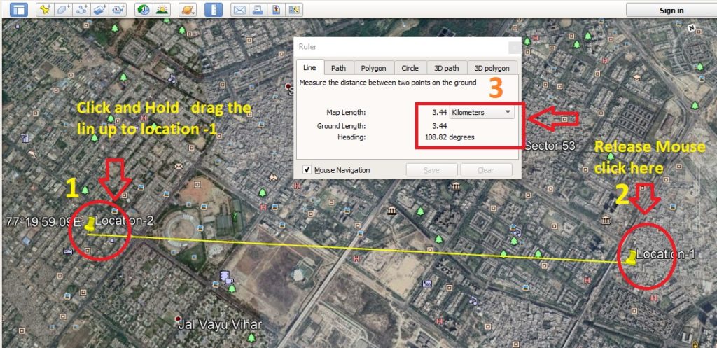
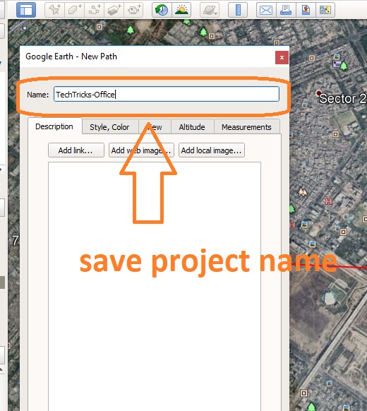
Click save button and type the name you want to give to this point to point project

how to connect 50Km wireless point to point


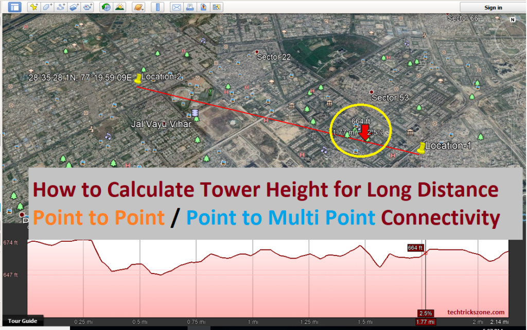
How to check Elevation profile in Google Earth for Wireless Point to Point.

This is the final calculation where we can calculate the tower height we required for point to point connectivity make it feasible.

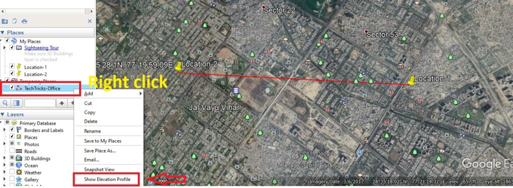
To open Elevation Profile Find the project name you have saved in the last steps.

Right-click the project name and click on Show Elevation profile.

how to check elevation in google earth for 50km ptp link

Now move the mouse cursor to Location 1 and see the Location 1 height from sea level.

Location 1- 665ft

How Do I Show Elevation on a Google Earth Map

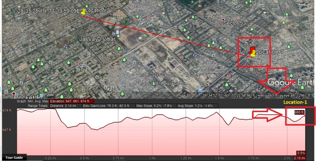
Location 2 sea level height – 671ft

PLANNING a 50KM PTP Link


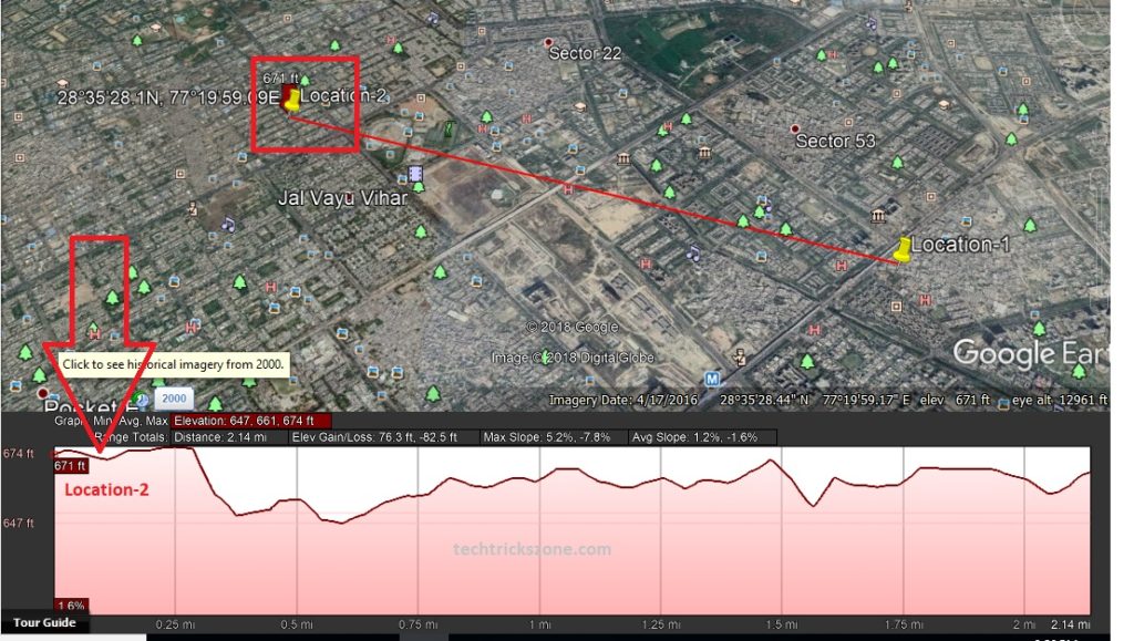
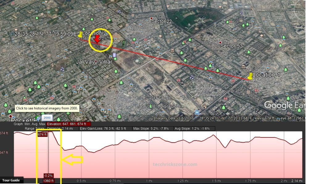
High raise obstacle between point to point links is 1 which has 674 ft.
You can move the mouse arrow toward other location you will get the high raise point as shown in red arrow mark with yellow.

120 Km link distance tower height check
Long distance point to point

Point to Point Link Calculation for Long-distance connectivity.

Now the calculation of point to point wireless link feasibility tower height required for long-distance.

  1. Location 1 existing building height is 20ft+ sea level 665ft = 685 ft.
  2. Location 2 existing building height is 0ft+ sea level 671 = 671ft

Obstacle height near Location be is 674 ft. which is 3 ft. more than location 2 sea level height

Location 1 – in location 1 we have already building height to pass obstacle height and clear Fresnel zone of link

685- 674= 11 (we have 11 ft. extra height to make Fresnel zone as well as obstacle clearance.)

Location 2

So here we required atlases 17 ft. tower height to make link feasible from location 1.

674-671= -3 (obstacle)

Location 1=   685-671 = 14+3(obstacle) =17 required height

We required 17 ft. tower height on location 2 to connect wireless point to point link.

Note – before installation and final tower height visit a physical inspection at the site and look both the site if there is any high tension electric line or any high rise building which is maybe under construction and will affect your link after the finish.


This is the basic calculation based on Google earth data you can also use many other Link planners like UBNT, Cambium link planner tools for long distance point to Multipoint and Point to Point site survey.

Video: Wireless Point to Point Site survey and Feasibility test with google earth


Related Post

  • What is the need for Wireless Site Survey?
  • How to Do Wireless Point to Point and Hotspot Site Survey

Filed Under: Site Survey, WiFi Tagged With: height of tower formula, height of tower formula in physics, how to find the height of a pole, how to find the height of a tower using trigonometry, how to indirectly measure height, how to measure telecom tower height, how to measure the height of a building, if the height of a tower and the distance of the point of observation from its foot

  • 7 Tips to Organize Your Study Space at Home
  • Best WiFi Routers for Gaming in Tri-Band [5GHz+5GHz+2.4GHz]
  • Love Archery? Check Out These Top-Notch Android Archery Games
  • 192.168.12.1 Default Login Admin Username and Password

Categories

  • 192.168.0.100 (1)
  • 192.168.1.245 (1)
  • 192.168.12.1 (1)
  • 192.168.178.1 (1)
  • 192.168.188.253 (1)
  • 192.168.2.1 (1)
  • 3C WiFi Router (1)
  • 4G Hotspot Router (2)
  • 4G LTE Router (1)
  • A2004NS Dual Band (1)
  • AC1200 (2)
  • AC1200 (1)
  • AC1200 (1)
  • Access Point (2)
  • Actiontec DSL Modem (1)
  • ADSL/VDSL Modem (1)
  • Airbrush (1)
  • AirFiber 5X (1)
  • AirGrid (2)
  • Airtel (4)
  • Airtel 4G Router (3)
  • Alexa Echo Show (1)
  • Amazon (1)
  • Android (5)
  • Anti Virus (1)
  • AP200 (1)
  • Apple (1)
  • Applications (4)
  • Archer C5400 (1)
  • Archery Game (1)
  • Arris (2)
  • Asus (3)
  • AT&T (1)
  • AX6000 (1)
  • Baby Monitor (1)
  • Backup & Restore (1)
  • Bandwidth Controll (1)
  • Bandwidth Management (1)
  • Beetel (1)
  • Beetel 77VR1 (1)
  • Belkin (1)
  • Belong (1)
  • Best WiFI router (1)
  • Binatone (7)
  • Block User in Airtel Xstream (1)
  • Blog (1)
  • Blogging (5)
  • Bootable Maker (1)
  • Brovis (1)
  • Business Management Software (1)
  • C20 (3)
  • C24 (2)
  • Cable Modem (2)
  • Canon G1000 (1)
  • Canon Pixma (1)
  • CAPsMAN Controller (1)
  • Captive Portal (1)
  • CCTV (6)
  • CCTV Brands (1)
  • CenturyLink (1)
  • Change WIFI Password (1)
  • Cloud (1)
  • Cloud Core Router (CCR) (2)
  • Comcast (2)
  • Computer Science Help (1)
  • Covr Mesh (1)
  • CP Plus (3)
  • CPE210/CPE220 (2)
  • CPE510 (2)
  • Cyberoam (1)
  • D-Link (3)
  • Data Backup (1)
  • Deco M (1)
  • Digisol (1)
  • Digital Marketing (1)
  • Dir615 (1)
  • Disc lite (1)
  • Drink Label Maker (1)
  • Driver Backup (1)
  • DSL 2750U (1)
  • DVR/NVR (1)
  • EAP2200 (1)
  • EAP225 Ceiling Mount AP (1)
  • EAP225 outdoor AP (1)
  • Educational (3)
  • Email Client (2)
  • Employee Monitoring (1)
  • EnGenius (3)
  • Epson (1)
  • Epson (1)
  • Epson L405 (1)
  • Esports (1)
  • EzyKam (1)
  • Facebook (19)
  • Facebook Game (1)
  • Facebook Reels Downloader (1)
  • Factory Reset Samsung Tab (1)
  • Fiber (3)
  • Fiber OLT (1)
  • Fiber Tools (1)
  • FireStick (1)
  • Firewall (2)
  • Firewall (1)
  • Firmware Upgrade (1)
  • Flying Voice (1)
  • Folder Lock (1)
  • Frontier (1)
  • FTP Client (1)
  • FTTH ONT/ONU (2)
  • Games (2)
  • Gargoyle (1)
  • Gmail (1)
  • Google Adsense (2)
  • Google Map (1)
  • GPON/EPON OLT (1)
  • Grammar check Tool (1)
  • Hap Mini (1)
  • Hathway (1)
  • Heatmap tool (2)
  • Hikvision (1)
  • Home Security (3)
  • Hosting (1)
  • Hotspot (2)
  • Hotspot (1)
  • How to (2)
  • HP (1)
  • HTM Editor (1)
  • HTML Homework Help (1)
  • HTTP to HTTPS (1)
  • Huawei (1)
  • iBall (4)
  • Ink Advantage wireless printer (1)
  • Instant Messenger (1)
  • Internet Meter (1)
  • iPhone (1)
  • ISO to MicroSD Converter (1)
  • Jio (2)
  • JioFi 4G Hotspot (1)
  • JioFiber (1)
  • JioFiber Router Reset (1)
  • Keyboard Shortcut (1)
  • L2 Switch (2)
  • L3 Switch (1)
  • Laptop (1)
  • LB-Link (1)
  • LB-Link Repeater Mode (1)
  • LGH (1)
  • LGH 5 (1)
  • Lightning Protection (1)
  • Linksys (2)
  • Linux (2)
  • LiteBeam (1)
  • Live Streaming (3)
  • Live TV (2)
  • Load Balancer (2)
  • Login IP address List (1)
  • Logo Maker (1)
  • M7350 MiFi (1)
  • Mac (1)
  • Manage Switch (1)
  • Marketing (1)
  • Medialink (1)
  • Mega Shows App (1)
  • Mercusys (3)
  • Mesh System (1)
  • MI (5)
  • MikroTik (15)
  • MIUI (1)
  • Mobile Game (1)
  • Modem login (1)
  • Monitor (1)
  • Motorola (1)
  • MS Office (2)
  • MW325R (1)
  • Nagios (1)
  • NAS Software (1)
  • Netgear (5)
  • Netgear R6220 (1)
  • Netgear WNR614 N300 (1)
  • Netis (1)
  • Network (4)
  • Network Tool (4)
  • Nova MW6 (1)
  • NVR (1)
  • online shoping (1)
  • Online Tool (1)
  • Online Video Maker (1)
  • OpenWRT (9)
  • Operating System (1)
  • Parental Controls (1)
  • Password Recovery (1)
  • PDF Password Remover (1)
  • PDF to Excel (1)
  • PDF to MS converter (1)
  • phone (2)
  • Photo Editor (1)
  • plugins (1)
  • point to Point (1)
  • Point to Point WDS Bridge (2)
  • Power Beam (2)
  • Printer (2)
  • Programming Courses (1)
  • Prosafe Switch (1)
  • Proxy sites (1)
  • QoS Setup (1)
  • Random Video Chat (1)
  • Range Extender (1)
  • Range Extender Mode (2)
  • RB3011 (1)
  • RedMi Note (3)
  • Repeater Mode (1)
  • Reverse PoE Switch (1)
  • Reviews (1)
  • Router reset (1)
  • RPoE Switch (1)
  • Samsung (1)
  • School Management (2)
  • screen recorder (2)
  • Security (5)
  • SEO (2)
  • Signal Booster (1)
  • Single Band Vs Dual Band (1)
  • Site Survey (2)
  • Social Network (20)
  • Software (25)
  • Software (2)
  • Sonicwall (1)
  • Sony (1)
  • Spectrum (1)
  • Surfshark VPN (1)
  • SyroTech (1)
  • Talon AD7200 (1)
  • Teamviewer Alternative (1)
  • Technicolor (1)
  • Technology (1)
  • Tenda (8)
  • Tenda AC10 (1)
  • Tenda ADSL Router (1)
  • Tenda N301 (1)
  • Tenda O6 5GHz (1)
  • Time Capsule (1)
  • TL-WA850RE (1)
  • TL-WR743ND (1)
  • TL-WR802N (1)
  • TotoLink (2)
  • TP-Link (28)
  • Trendnet (1)
  • TrendNET N300 (1)
  • Twitter (2)
  • Twitter (2)
  • UAG50 (1)
  • Ubee (2)
  • Ubee DDW320 (1)
  • UBNT (10)
  • Unifi Controller (2)
  • USB Bootable Maker (1)
  • Vaio E Series (1)
  • Video (3)
  • Video Converter (3)
  • Video editor (2)
  • Voip Phone (1)
  • Voltek (1)
  • VPN (2)
  • VPN (1)
  • VPN Router (1)
  • Watermark Removal (1)
  • Wavlink (1)
  • WBS-510 (1)
  • WhatsApp (1)
  • WhatsApp (2)
  • WhatsApp (1)
  • WiFi (17)
  • WiFi Router (15)
  • WiFI router (1)
  • Windows (11)
  • Wordpress (2)
  • WordPress (1)
  • WR-3010N (1)
  • WR1505/WR3005 (2)
  • WR3000N (1)
  • WR820N (1)
  • Xfinity (2)
  • YouTube (4)
  • YouTube Downloader (2)
  • Zyxel (1)
  • How To Change Hathway WiFi Password- User Manual
  • 7 Tips to Organize Your Study Space at Home
  • Best WiFi Routers for Gaming in Tri-Band [5GHz+5GHz+2.4GHz]
  • Love Archery? Check Out These Top-Notch Android Archery Games
  • 192.168.12.1 Default Login Admin Username and Password

Recent Posts

  • How To Change Hathway WiFi Password- User Manual
  • 7 Tips to Organize Your Study Space at Home
  • Best WiFi Routers for Gaming in Tri-Band [5GHz+5GHz+2.4GHz]
  • Love Archery? Check Out These Top-Notch Android Archery Games
  • 192.168.12.1 Default Login Admin Username and Password

Tags

192.168 0.101 tenda login admin airtel 4g hotspot connected but no internet airtel 4g hotspot login airtel 4g hotspot no service asus router login best wifi router best wireless router for home binatone router bridge mode binatone dt920w as repeater binatone router cp plus app cp plus camera online view cp plus dvr firmware update download cp plus ip camera cp plus login how to block websites in router tp-link how to block adults websites on my router how to block websites on network how to buy router for home iball baton login mikrotik routerboard netgear modem login netgear modem setup netgear router login netgear support openwrt transparent bridge tenda n300 login tenda router tenda router setup tendawifi.com login tenda wifi tp-link login tp-link router tp-link router login tp-link tl-wr820n as repeater tp-link login username and password tp-link router as repeater tp link tl-mr6400 setup tplinkwifi tp link tl-wr840n range extender ubnt use binatone router dt910w as repeater which wifi router is best for me wifi extender wr1505n3 binatone configuration

Copyright © 2023 & Powered By Genesis Framework